
GP1970F
GPS/WAAS CHART PLOTTER with built-in CHIRP FISH FINDERModelGP-1971F
Powerful technology in a compact 9" Chart Plotter with Built-in CHIRP FISH FINDER !
Recreational Boats
Features
-
FURUNO 2019 "Your adventure begins!" -
The Ultimate Combo Units
-
Multi-Touch Interface
◆Convenient and intuitive slide-out menus
The GP-1871F/1971F smart interface, inherited from the NavNet TZtouch2,
features slide-out menus containing all the tools and data you need to be in total control.
Quick page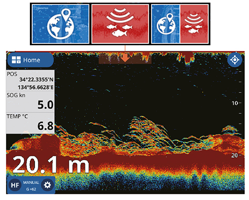
DATA BOX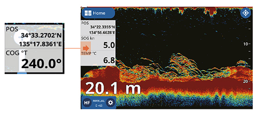
Slide-out Menu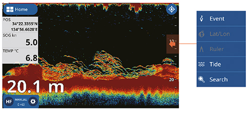
Layers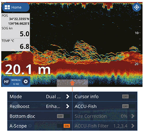
◆Display modes customization
Customize your display modes and create the perfect
combination to fit your individual needs.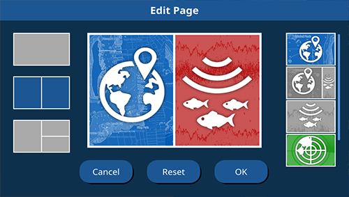
Customization menu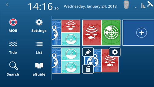
Main Menu and Display mode setting
◆Finger Gestures
With the Finger Gestures (one or two fingers) you can either zoom-in, zoom-out, double tap to take a screenshot or even jump to a full-screen mode when using Split-screen display mode.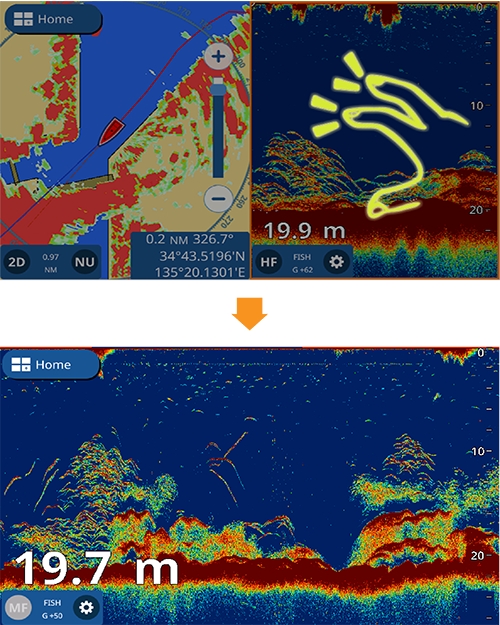
◆Easy screenshot and MicroSD card
Tap the display with two fingers to capture a screenshot
that will be saved directly to your micro SD card.
-
Built-in CHIRP FISH FINDER
◆ Unmatched detail with TruEcho CHIRP™
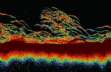
The high level of detail available with TruEcho CHIRP™ technology helps to distinguish fish schools, even when close to the sea bed.
Fish can be observed with a very high resolution and are displayed in a distinct boomerang shape. The clear presentation marks individual game fish and bait fish, even when tightly schooled together.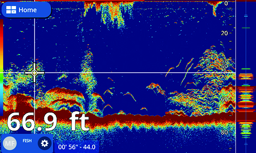
◆ ACCU-FISH™ and Bottom Discrimination with RezBoost™
With FURUNO’s RezBoost™ data processing technology, fish schools and echoes are shown with high resolution while you can assess fish size and bottom composition thanks to ACCU-FISH™ and Bottom Discrimination functions.
Additionnaly, ACCU-FISH™ icons and colors can be freely customized according to the size and depth of the targeted fish.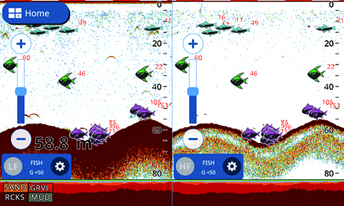
-
Chart Plotter (with internal GPS antenna)
◆ Detailed Chart with C-MAP 4D compatibility
By using the incredibly rich C-MAP 4D charts, the GP-1871F/1971F delivers highly precise data that features plenty of useful information, such as relief vectors, tidal streams and marine plans, considerably enhancing your navigational awareness.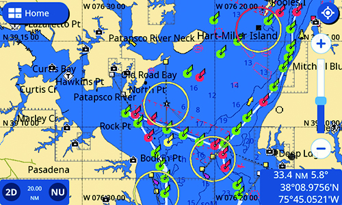
C-MAP Chart data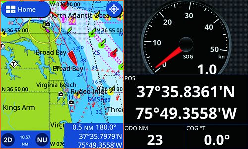
Chart Plotter with instruments panels
◆ Autopilot controls
Via the CAN bus network interface, The NAVpilot-300 and NAVpilot-711C can be connected to the GP-1871F and GP-1971F and controlled directly from the Chart Plotter.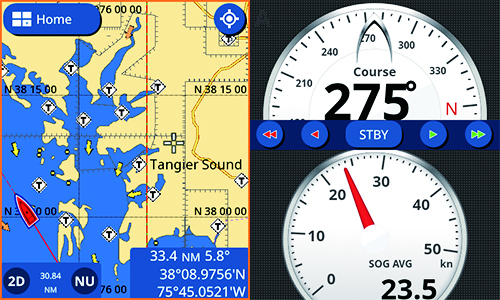
Chart Plotter with NAVpilot controls
◆ C-MAP C-Weather
C-Weather data can be downloaded from C-map.com providing Wind, Wave, Weather, Humidity and Temperature information.
◆ Plotter with AIS symbols
When connected to an AIS receiver, the GP-1871F/1971F will display the latest AIS data and provide vessel information.
◆ Various display modes
Including Shaded reliefs, 3D and Satellite views. -
Wireless Radar Connection
◆ DRS4W 1st Watch Wireless Radar
The GP-1871F and GP-1971F are connectable to the 1st Watch Wireless Radar
(Output Power 4 kW) giving your Chart Plotter a major upgrade in accuracy and safety.
Plotter Overlay mode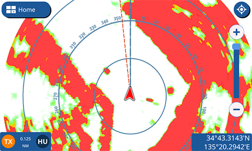
Radar mode
-
Easy screenshot and MicroSD card
Tap the display with two fingers to capture a screenshot
that will be saved directly to your microSD card.
-
AF (Anti-finger print) treatment on AR glass (GP-1971F)
-
AR (Anti-Reflective) glass coating and strengthened glass filter
-
Internal GPS antenna for simple and easy installation
-
Daylight viewable with excellent readability , brightness of 1000 cd/m2
Specifications
Display Unit
- Screen Type
- GP-1971F: 9" Wide Color TFT LCD
- Screen Resolution
- WVGA 800 x 480 pixels
- GPS Antenna
- Internal Antenna
- Display Modes
- -Chart Plotter
-Fish Finder
-Radar (connection to the 1st Watch Wireless Radar DRS4W required)
-AIS (connection to AIS sensor required)
-Instruments (Nav Data, Engine, Wind, Fuel tank) -
-Autopilot (connection to the FURUNO NAVpilot-300 or 700 series required) - Language
- English (US & UK), French, Spanish, German, Italian, Portuguese, Danish, Swedish, Norwegian, Finnish, Greek, Japanese.
GPS / SBAS (WAAS/EGNOS/MSAS)
- Receiving Type
- GPS 72 channels
WAAS 1 channel - Receiving Frequency
- L1 (1575.42 MHz)
- Accuracy
- GPS: 10 m max, WAAS: 5 m max, MSAS: 7.5 m MAX
PLOTTER
- Chart
- C-MAP 4D
- Memory Capacity
- 30,000 points for ship's track and waypoints
1,000 planned routes (Max. 50 points per route)
5,000 quickpoints
FISH FINDER
- Frequency
- CHIRP: 40 to 225 kHz
CW: 50/200 kHz - Transducer
- 300 W or 600 W or 1kW (Transducer dependent)
- Range
- 5-1, 200m, shift :0-500m
- Modes
- TruEcho CHIRP™*, RezBoost™**, ACCU-FISH™**, Bottom Discrimination**, Dual Frequency**, Dual Range** Auto gain (Fishing/Cruising), Manual gain, A-Scope, Marker Zoom, Bottom Zoom, Bottom Lock
* CHIRP dedicated transducer required
** Dual frequency CW compatible transducer required
Interface
- NMEA2000
- 1 port (Interface CAN bus)
Input: 126992, 127245, 127250, 127251, 127258, 127488, 127489, 127493, 127497, 127505, 128259, 128267, 128275, 129025, 129026, 129029, 129038, 129039, 129040, 129041, 129284, 129285, 129538, 129540, 129793, 129794, 129798, 129808, 129809, 129810, 130306, 130310, 130311, 130312, 130313, 130314, 130316, 130577, 130830, 130831, 130832, 130880
Output:126992, 127245, 127250, 127251, 127257, 127258, 127505, 128259, 128267, 128275, 129025, 129026, 129029, 129033, 129283, 129284, 129285, 130306, 130310, 130312, 130316, 130830, 130831, 130832 - NMEA0183
- 1 port
Input: DBT, DPT, DSC, DSE, GGA, GLL, GNS, HDG, HDT, MTW, MWV, RMC, ROT, RSA, THS, TLL, VDM, VHW, VTG, ZDA, PFEC (GPatt/SDmrk/SDtbd/SDtfl/pireq)
Output: AAM, APB, BOD, BWR, DBT, DPT, GGA, GLL, GNS, GSA, GSV, GTD, HDG, HDT, MTW, MWV, RMB, RMC, RTE, THS, TLL, VHW, VTG, WPL, XTE, ZDA, PFEC (SDmrk/SDtbd/SDtfl/pidat) - Other
- Micro SD Card Slot x2 (32 GB)
OTHERS
- Waterproofing
- IP56
- Power Supply
- GP-1971F: 12-24 VDC, 1.0-0.5 A
- NMEA2000: 1 port
NMEA0183: 1 port * Software version 1.1 or later

